Glossary Term
GNSS
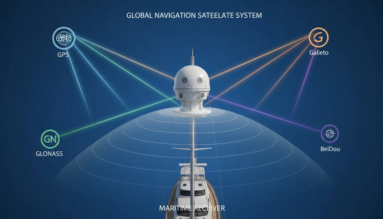
GNSS stands for Global Navigation Satellite System. It is the umbrella term for satellite constellations that provide positioning, navigation and timing data. GPS is one GNSS, but it is not the only one. Galileo, GLONASS, BeiDou and some regional systems also fall under the same broader category. In other words, GPS is a member of the GNSS family, not a synonym for the whole thing.That distinction matters on yachts because modern maritime receivers are often designed as multi-system receivers. IMO performance standards describe shipborne equipment that can use signals from two or more GNSS, with or without augmentation, to provide position, velocity and time data for navigation and other shipboard functions. The practical benefit is straightforward: more available signals, more redundancy, and better resistance to the loss or degradation of a single system.
What GNSS actually does on board
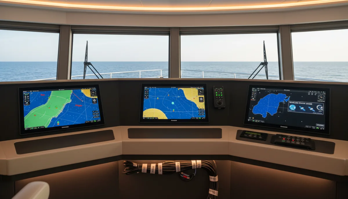
A GNSS installation usually consists of an antenna, a receiver, processing logic and interfaces to the rest of the yacht’s systems. The receiver listens to timing and ranging signals from satellites, calculates position, then outputs related data such as course over ground, speed over ground and UTC time. On a yacht, that information may stay visible on a dedicated display, but in many cases it is also distributed to other equipment through the wider bridge and electronics network, sometimes over interfaces such as NMEA 2000 or other marine data links.
This is why GNSS is better understood as a position, navigation and timing source than as a standalone gadget. IMO guidance on shipborne PNT data processing specifically connects resilient PNT data with bridge teams and shipboard applications such as AIS and ECDIS. That is the operational reality on many yachts: GNSS is one of the inputs other systems depend on, whether the crew notices it day to day or not.
Where it matters in real yacht operations
GNSS becomes especially visible when the yacht is moving through tighter or more data-heavy navigational situations. Route monitoring, track control, AIS reporting, charted position display and time-synchronised equipment all depend on reliable underlying data. IMO performance standards also note the role of augmentation services in areas such as harbour entrances, harbour approaches and coastal waters, which is exactly where positioning confidence tends to matter most to bridge teams.
For that reason, captains, ETOs, engineers, surveyors and yacht managers do not look at GNSS as a single screen on the bridge. They look at the full chain: antenna siting, signal quality, receiver behaviour, integrity indications, data outputs, alarm handling and how downstream equipment reacts. If the yacht’s displayed position is wrong, the real question is often not “is the GPS broken?” but “which part of the GNSS and PNT chain is failing?”
What can go wrong
The weakness of GNSS is that it depends on radio signals arriving from space at very low power. That makes it vulnerable to both accidental and deliberate interference. In March 2025, IMO, ICAO and ITU issued a joint statement expressing grave concern over increased jamming and spoofing affecting satellite navigation systems and called for stronger protection, resilience and reporting.
On board, interference does not always announce itself neatly. A receiver may still show some form of data while the information is degraded, inconsistent or misleading. IMO guidance on electromagnetic compatibility and interference advises crew, maintainers and surveyors to use the unit’s SNR or integrity display mode when checking for GNSS interference, and recommends fuller investigation with a spectrum analyser if the source cannot be identified. It also says the findings should be documented and the report kept on board.
That is also why multi-system capability should not be misunderstood as immunity. Using more than one constellation can improve resilience and help mitigate the loss of a single system, but it does not remove the need for cross-checking, conventional navigation backups and sensible bridge awareness. The 2025 IMO-ICAO-ITU statement explicitly called for maintaining conventional navigation infrastructure as contingency support.
GNSS is not the same thing as GPS, ECDIS or AIS
The most common confusion is simple: people say GPS when they really mean GNSS. Technically, GPS is the U.S. constellation; GNSS is the broader category. A second confusion is between the position source and the systems using that source. ECDIS is a chart display and route-monitoring system. AIS is an identification and reporting system. Neither is the same thing as GNSS, even though both may depend on GNSS-fed position and timing data to function properly.
That distinction helps when diagnosing faults. If AIS targets look wrong, that does not automatically mean the AIS unit itself is the root problem. If the charted own-ship position appears unstable, the issue may not begin inside ECDIS. On a yacht with interconnected systems, one weak GNSS feed can create symptoms in several places at once.
Why GNSS deserves attention during refit and survey
GNSS often gets more attention during refit than it does in routine operation, because changes elsewhere can affect it. New mast structures, antenna relocations, cable runs, bridge upgrades, replacement displays, network reconfiguration and integration work can all alter how position and timing data is received, assessed and distributed. Maritime performance standards treat the antenna arrangement, receiver capability, displayed quality information and shipboard interfaces as parts of one working system, not as isolated items.
That is why GNSS checks belong in condition assessment, commissioning and sea trial thinking. The job is not only to confirm that the receiver produces a position, but to confirm that the data is stable, credible, correctly distributed and properly interpreted by the equipment downstream. On a complex yacht, that difference can affect navigational confidence, troubleshooting time and the scope of follow-on electrical or electronics work.
GNSS, then, is best understood as the satellite-based position, navigation and timing layer behind much of modern yacht navigation. Once you see it that way, the term becomes much more useful. It is not just a label on a receiver. It is part of the yacht’s wider navigation architecture, and when it is misunderstood, the effects spread quickly.
FAQs
Is GNSS the same as GPS?
No. GPS is one satellite navigation system, while GNSS is the wider category that includes GPS, Galileo, GLONASS, BeiDou and others. On many yachts, people still say “GPS” in everyday conversation even when the receiver is actually using several constellations together.
Why do modern yachts use multi-system GNSS receivers?
A multi-system receiver can use signals from more than one satellite constellation, which generally improves availability and redundancy. In practical terms, that gives the bridge a better chance of maintaining a stable position, velocity and time solution if one system is degraded or unavailable.
Does GNSS only affect the navigation screen on the bridge?
Usually not. GNSS data is often distributed to other onboard systems and applications, including charting, monitoring and reporting functions that rely on shared position or timing data. That is why one GNSS problem can show up in several places at once rather than staying inside one display.
How do crews usually notice GNSS interference or spoofing?
The first signs are often indirect: unstable position data, unexpected movement on the chart, inconsistent timing, or downstream equipment behaving oddly. IMO guidance also points to using the receiver’s signal-to-noise or integrity display mode when interference is suspected, rather than assuming the displayed position is trustworthy just because the unit is still producing data.
Can a yacht rely on GNSS alone for safe navigation?
No sensible bridge team treats GNSS as the only layer of navigation assurance. Recent joint guidance from IMO, ICAO and ITU highlights the increase in jamming and spoofing incidents and reinforces the need for resilience, cross-checking and backup methods.
Is GNSS a compliance issue on commercial yachts?
It can be. Once a yacht falls under commercial operation, code requirements, flag-state expectations, class rules and applicable IMO performance standards can all affect what equipment is installed, how it is interfaced and how it is expected to perform. The exact obligation depends on the yacht’s certification basis, so GNSS should be reviewed in the context of the vessel’s full regulatory setup, not as a generic consumer-electronics feature.
What should be checked after a bridge refit, antenna move or electronics upgrade?
The key point is not just whether the receiver still outputs a position. Crew and technical teams should also confirm signal quality, correct data distribution, alarm behaviour, time synchronisation and how dependent systems respond during dockside checks and sea trials.
Does every GNSS-related problem mean the receiver itself is faulty?
Not at all. The issue may come from antenna placement, cable problems, interference, network distribution, integration errors or how another system is interpreting the incoming data. On a modern yacht, troubleshooting GNSS usually means checking the whole PNT chain rather than blaming one box too early.
Who on board actually needs to understand GNSS?
Captains and bridge teams need the operational picture, but ETOs, engineers, surveyors, managers and owner-side representatives also benefit from understanding how GNSS feeds other systems. It becomes especially relevant during troubleshooting, surveys, upgrades, refit planning and acceptance testing.